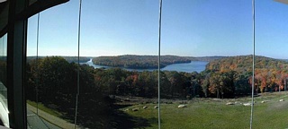
Kensico Reservoir 21-Oct-99
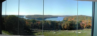 Kensico Reservoir 21-Oct-99
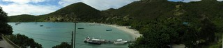
 Panorama of Carlisle Bay off Old Road.
 Jolly Harbour Beach.
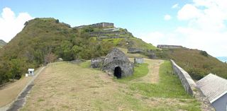 Brimstone. A small panorama. The Magazine is front center.
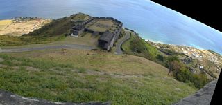 Looking down at the Prince of Wales Bastion at Brimstone. This is what you get when you stitch two pictures that weren't taken with the intention to stitch them.
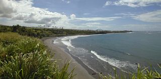 A small panorama of Sandy Bay.
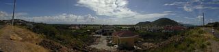 A 180 degree panorama overlooking some homes, then past it is the Royal St. Kitts Golf Club. Taken from the Conaree Hills.
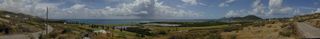 A good panorama of the Royal St. Kitts Golf Course. This picture is old. The golf course is now jointly owned by the Government and Marriott and is being managed by Marriott. The whole course was completely redone.
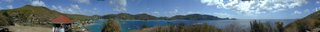 Panorama of Admiralty Bay. Taken from Old Fort. 20 overlapping pictures were stitched together to get 360 degrees. Many hours of work!
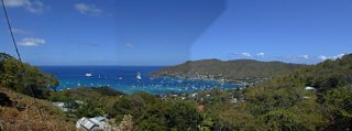 A panorama of Admiralty Bay looking North. I must not have used exposure lock. Maybe someday I'll lighten the center image and restitch.
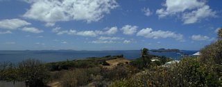 A panorama of The Grenadines taken from the ruins of what was to be a hotel on St. Hillaire Point.
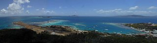 The air strip from Fort Hill. Close tiny island is Red Island. Behind is Palm Island. Petit St. Vincent is the island in the middle. Carriacou is the large island in the distance at the right. Clifton is at the far right.
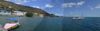 After wasting the morning trying to find someone to fix my flat tire I took a bus out to the town of Dover at Windward. This is a picture of Bay á L'Eau from the dock facing north. As you can see I didn't use exposure lock, and maybe someday I'll figure out how to adjust the exposure on the orginals and restitch.
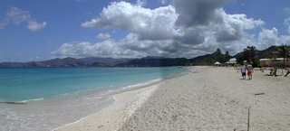 Grand Anse Bay with St. Georges in the far background. The two pictures didn't stitch so well.
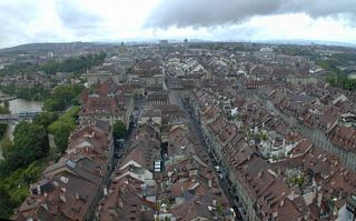 Another view from the top of the Cathedral. Two pictures stitched together. Facing west.
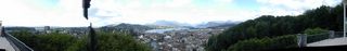 A panorama of Luzern taken from Chateau Gutsch. A lot of work getting this one stitched (and some Photoshop work is still needed). Be sure to scroll to the middle where the view is.
 A 360 degree panorama taken from Gibbs Hill Lighthouse.
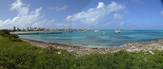 Island Harbour with Scilly Cay being the island to the right. It has an open-air restaurant and bar. Open during the day only.
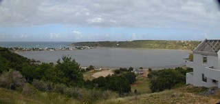 The Road Salt Pond at Sandy Ground. Sandy Ground is the strip of buildings along the left. North Shannon Hill is behind.
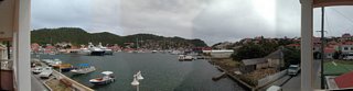 Gustavia Harbor. Taken from the balcony on La Presqu'île, where I stayed.
 One of my best panoramas! Taken from Hannah Moser's Gallery in Devet facing northeast.
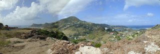 Looking at Morne Vitet. Standing on Petit Cul de Sac [??]
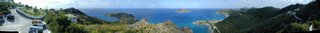 Standing on Le Ti' Morne looking north. Another of my best panoramas. Be sure to scroll past the cars. The sailboats are in Anse du grand Colombier. Then Pointe a Colombier. Then Anse Paschal. Then La Petite Anse, cut off at the picture bottom. Then Anse des Flamands, with the sand along the right.
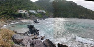 La Petite Anse.
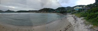 [DSCN5107d] Anse des Cayes [??]
 Baie de St. Jean, and beach. Picture taken at the far end past the airport and looking back at Eden Rock (sticking into the bay).
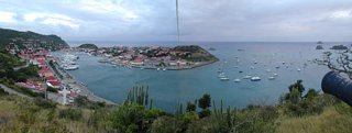 Gustavia Harbor from Fort Gustave. This was stitched from two pictures with little overlap. I don't think I was planning to stitch.
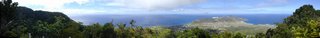 A really good panorama looking northwest from The Quill. Oranjestad is the town to the left. Golden Rock and Concodia are the towns in the center of the island, though they kind of run together. This is the only place on the island that you can see the oil refinery.
 A panorama taken from my seat as I was waiting for breakfast. Exposures weren't very consistent! I guess when I was taking the pictures I wasn't planning on stitching them. Be sure to scroll to the right. It's better than the left.
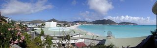 A view back at Philipsburg on my way up to Fort Amsterdam.
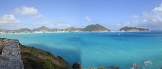 A view of Great Bay from Fort Amsterdam.
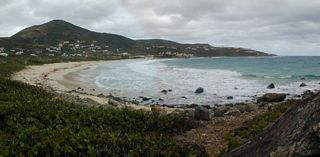 Guana Bay.
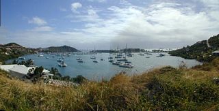 Oyster Pond.
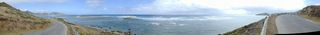 Baie de l'Embouchure.
 Baie de l'Embouchure. Taken from the viewing stand.
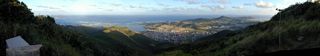 A good panorama from the top of Colombier looking east. Orleans is the town below.
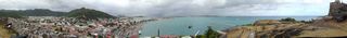 A lovely panorama of Marigot from Fort Louis. In the center is the ferry to Anguilla boarding people.
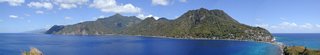 A very good panorama of Soufriere Bay taken from Scott's Head. Soufriere is in the middle. And Scott's Head Village is the cluster at the other end of the causeway.
 Then I decided to take a panorama. But waves don't stitch well. And clouds were moving overhead.
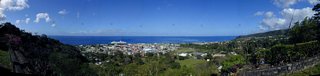 Before I left I walked up to the lookout at Morne Bruce and got a panorama of Roseau. Unfortunately there was a spot on my lens.
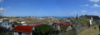 A panorama looking down at Le Vanclin. 11:28
 A panorama. The scene is nice, but clearly I didn't bother with exposure lock and it shows. Looking at [??]. Taken at [??]. DSCN5791b 3:27
 From a stop on the Route de la Traversée. A panorama looking north. 9:25
 A panorama looking east towards Point-à-Pietre. Taken from behind Gîte de Mamelles. Or from Morne à Louis. [??] 9:38
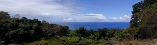 At the end of the Jardin Botanique de Desharies. Looking west.
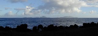 A panoramic view of Les Saintes from Trois-Riviéres.
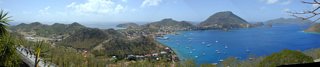 A good panorama taken from Fort Napoléon looking at Bourg des Saintes and Anse du Bourg.
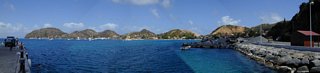 A panorama taken on the pier at Plage de L'Anse À Gilot. Looking at Anse du Bourg.
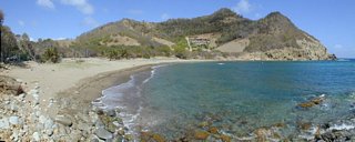 A panorama of Plage du Figuier.
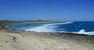 Taken from the Pointe des Châteaux looking west along the Atlantic side.
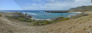 Near the Cotton Mill ruins. Baie Mahault is in the distance to the right. Pointe Gros Rempart sticking out in the middle.
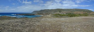 Cotton Mill ruins is in the center. Baie Mahault behind it.
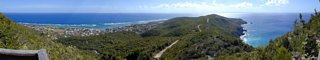 Panorama taken from the small chapel with lookout. Grande Anse down below. I came on the road along the ridge to the right. Going back I took the road straight down. It was paved and very quick.
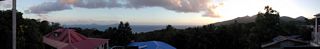 I returned to Basse-Terre a week later. A panorama from my terrace at Le Joyeux, the place I stayed in Faubourg, near Trois-Riviéres. Les Saintes in the distance.
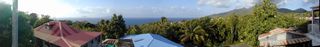 The next morning I took another panorama from the terrace.
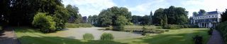 The gardens at Vollenhoven were open for the weekend. A nice panorama here of the home and its view.
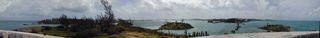 From Martello Tower on Ferry Point. Looking at The Causeway and Castle Harbour beyond. The remains of the train trestle are to the right.
 A 360 degree panorama from St. David's Lighthouse.
 360+ panorama from Ceroe Grandi. As the view comes out from the hill you have Oranjestad way in the distance. Then the high rises of Palm Beach are noticeable. Then the lighthouse can be found.
 360 panorama from top of Bushiribana Gold Mill Ruins.
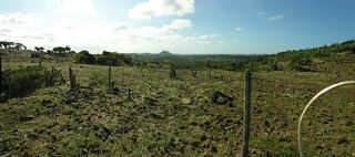 On my way out from the Natural Pool. In Arikok National Park. Looking west towards Oranjestad. A two image panorama. My last picture of the day.
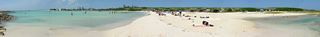 Panorama of Baby Beach.
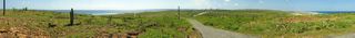 Panorama from the Seroe Colorado Lighthouse hill. As the view comes out from the hill you have the Cabez Reef. Then the Dunes. Then Baby Beach. Seroe Colorado is in front of the refinery. When the view is looking north up the east coast, you will see a low yellow building. That's the prison.
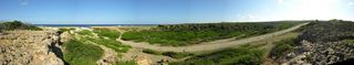 A panorama of Boca Prins. I had to bike through the water which you can see on the road coming from the coast.
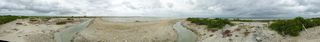 360 Panorama of the solar salt works.
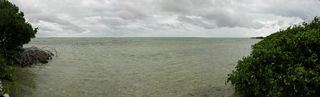 Little panorama looking into the salt flats. Possibly at Witte Pan.
 Panorama view from Willemstoren lighthouse.
 Panorama of Salina Frans.
 A panorama on the north coast at the turn off to Boka Onima. In the middle you can see the bike group from the cruise ship.
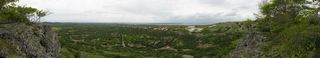 Panoramic view from Seru Largu. I walked though the woods to get this view right after I made it up there.
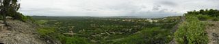 Another panoramic view from Seru Largu. Where the road came up to the edge.
 Another panoramic view from Seru Largu. Then I come to the official lookup. But I don't think it makes as good a picture.
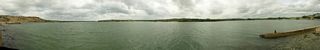 Panorama of the Lagun.
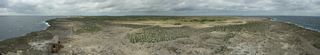 Panorama of Boliva from the Spelonk Lighthouse. See bike path alongside red house. I did not know about this until chatting with a fellow as I waited to leave the island. I came by the road in the middle. And left by the one to the right.
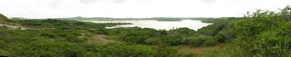 A panorama of Lagun Jan Thiel. Looking east. The Bon Future Prison is off the picture to the left.
 A panorama looking west at Lagun Jan Thiel.
 A panorama from a house that was being built on the top of a hill in Brakkeput Abbou. Like it? Call 694-2095 if you want to buy it.
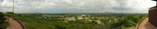 When I stopped for some water in Caracasbaai a fellow recommended I make it up Midden Seinpost (104 meters). This is a panorama looking east and south towards the water.
 I then climbed up a small observation tower and took a 360 degree panorama. The first body of water is Lagun Jan Thiel to the south. I couldn't get the horizon straight. Someday I'll try to fix it.
 I made it up to Fort Nassau. Now a restaurant. This is a panorama looking at the Queen Juliana Bridge. Taken from the front steps.
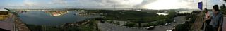 I then when up onto the fort and got a better panorama. Zeelandia and then Salina are the first towns seen.
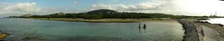 A panorama the next morning. Taken from the jetty along the Koredor Jogging Track (a.k.a. John F. Kennedy Boulevard). At the far right is the water and electricity plant.
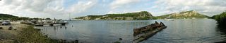 From the other end of the boats I got a panorama of Piscadera baai.
 A panorama looking south from the pier of De Octopus Bar at Boka Sami.
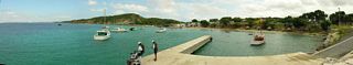 I went a little ways to the south and took a panorama looking back at De Octopus Bar. Poor fellow moved and got duplicated.
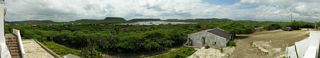 A panorama from Landhuis Jan Kok. Looking south over the salt flats where the flamingos gather.
 A panorama of Deaibooi baai.
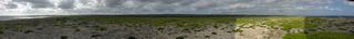 The next day I rented a car. This panorama taken west of the airport. My car is just a spec in the middle. As I was taking the pictures the sun came out briefly for two of them.
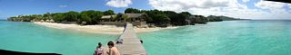 A panorama of Playa Kalki taken from the pier.
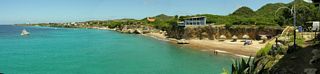 A panorama of Playa Forti from the bar/restaurant.
 A panorama from the mountain drive in Christoffel Park. Looking north.
 Another panorama from the mountain drive in Christoffel Park. Looking northeast.
 Yet another panorama from the mountain drive in Christoffel Park. Again looking northeast.
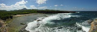 A panorama closeup of the Boka Grandi.
 Another panorama of Boka Grandi.
 A panorama from Negrita looking across the Waaigat at Punda. Unfortunately the first picture was into the sun, so the then locked exposure was all wrong for the rest. I should have taken a throwaway picture in the center first.
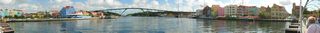 A very nice panorama from the Queen Emma bridge looking north to the Queen Juliana bridge.
 A panorama from the Århus Domkirke tower. Facing north.
 I bicycled along the water as far as I was allowed to on the free bike. Then in Marselis I took this panorama.
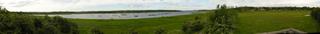 A panorama taken from a viewing stand near Gellerup. Brabrand Sø is the body of water. [Is the horizon straight?]
 A panorama taken between Gålten and Lasby. Facing south.
 A panorama of Løgten Bugt.
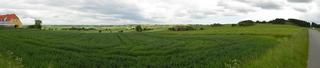 A panorama of Mols Bjerge.
 A 360° panorama from a dike in Ny Frederikskog. (South of Højer.) The cloud cover kept changing as I was taking the pictures.
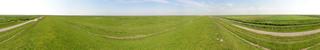 I climbed up on the dike overlooking Ballum Sluse to take this 360° panorama.
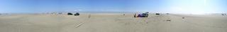 A 360° panorama of Lakolk Strand.
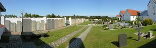 A panorama of the unique Greenlandic gravestones at the Rømø Kirke.
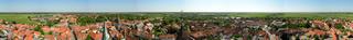 A 360° panorama from the Ribe Domkirke.
 A 360° panorama taken near Tråsbøl.
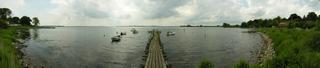 A panorama from Alnor.
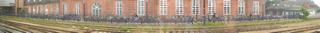 While my train was stopped in Odense I took this panorama out the window of a long row of bicycles. It was raining, and the focus isn't consistent between images.
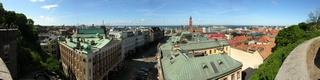 A panorama from the viewing bridge looking over Helsingborg. The town hall is the tower in the middle.
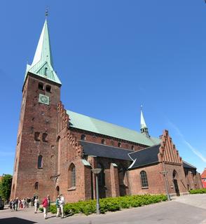 The Sankt Olai Kirke. This is two pictures stitched, one over the other. It was hemmed in by other buildings and I couldn't walk back.
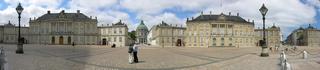 A panorama of the Amalienborg Slot. This is just two of the four buildings. The royal family lives in them. In the middle of the picture you can seen the Marmorkirken.
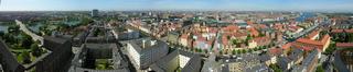 A panorama from the tower of Vor Frelsers Kirke. Looking west. Christianshavn with its canal is in the foreground. Then the city of Copenhagen is beyond.
 A panorama from the tower of Vor Frelsers Kirke. Looking east.
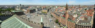 A panorama from the City Hall tower. Looking north-west. The Rådhuspladsen is in the foreground.
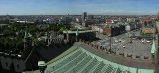 The third and fourth pictures of the south-west panorama. Tivoli is along the left.
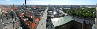 A panorama from the City Hall tower. Looking south-east. Tivoli again appears at the far right.
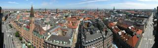 A panorama from the City Hall tower. Looking north-east.
 A panorama from the Round Tower. This was a hard one to stitch. It is a wide tower. We were kept far from the edge. And it isn't very high.
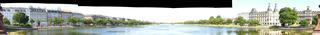 A terrible panorama of the Sortedams Sø. The exposure is wrong. The pictures don't line up.
 The head of Barnegat Bay taken from the Bay Head Yacht Club on 06-Aug-05.
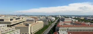 From the Old Post Office Tower in Washington, DC. Facing East. In this direction (and the next two) they had vertical wire bars one inch apart. You weren't supposed to touch them. But I was able to squeeze my lens between them to get the pictures.
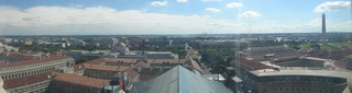
 From the Old Post Office Tower in Washington, DC. Facing North.
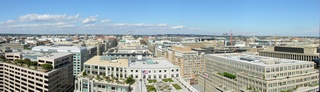
 From the Old Post Office Tower in Washington, DC. Facing West.
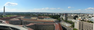
 From the Old Post Office Tower in Washington, DC. Facing South. In this direction they had a large window, which wasn't very clean on the outside.
 The view outside my room. Foxy's dock is down in front.
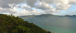 On East End Road. Looking at Tortola.
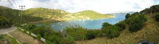 Looking down at Little Harbour. Abe's is the bright white largest building at the water towards the right. Scroll over.
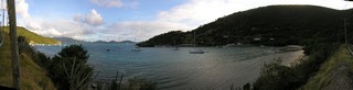 Looking out Little Harbour with Tortola in the distance.
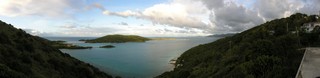 Looking out at Little Jost Van Dyke. The sailboats are in Long Bay. In front is East End Harbour.
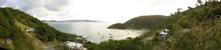 Looking out Little Harbour with some little islands and St. Thomas in the distance.
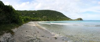 A small panorama of Smuggler's Cove with Gun Point. Having breaking waves in a panorama is problematic.
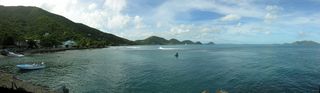 Carrot Bay.
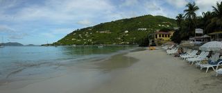 Cane Garden Bay.
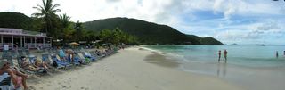 Cane Garden Bay.
 Looking down at Cane Garden Bay.
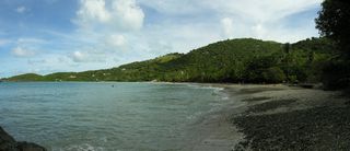 The panorama version of the beach at Brewer's Bay.
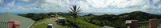 A wide panorama taken from above Skytop Restaurant. Looking towards the east.
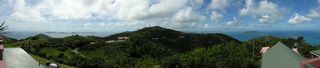 Another wide panorama taken from Skytop. Looking towards the north.
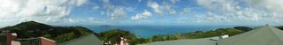 Another wide panorama taken from Skytop. Looking towards the west.
 A panorama of the island's east end, taken from the scenic lookout on the Sage Mountain Joseph R. O'Neal Trail (#5). The bays in the foreground are Sea Cow and Nanny's Cay.
 Another panorama of Sea Cow Bay and Nanny Cay. Taken from the scenic lookout on the Sage Mountain Joseph R. O'Neal Trail.
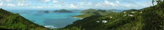 A panorama looking at Guana Island from Manchester, Belle Vue along the Ridge Road heading towards East End.
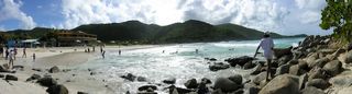 A panorama of the beach at Josiah's Bay.
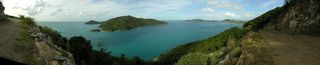 A more than 180° panorama of Guana Island. Taken on the road past the prison.
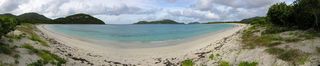 A more than 180° panorama of Long Bay on Beef Island.
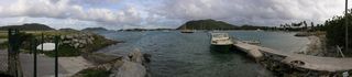 A panorama of Trellis Bay. Facing east.
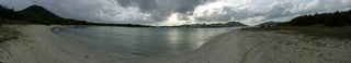 A panorama of Trellis Bay. Taken from Sprat Point and facing west.
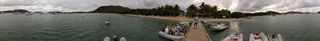 A 360° panorama of Trellis Bay taken from the dock in front of the Loose Mongoose. I need to output as multi-layer Tiff and mask out the fellow appearing multiple times.
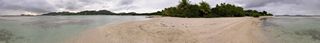 A 360° panorama of Well Bay, on Beef Island.
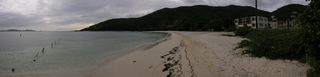 A panorama of the beach on the east side of Brandywine Bay.
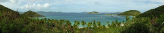 A panorama overlooking Deadman's Beach.
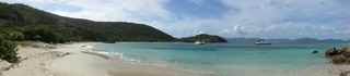 A panorama of Deadman's Beach.
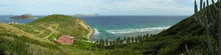 The panorama version of the previous scene. This now stretches over to include Reef Bay to the right.
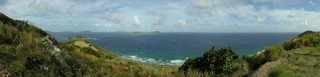 A panorama looking over Reef Bay. Taken from a concrete slab near the communications tower.
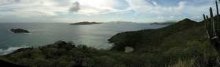 From "The Loop" looking southwest. The island to the right is Norman Island. In the lower right is Stoney Bay.
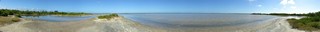 A panorama of Vagabond Pond. In the far distance is Flamingo Pond.
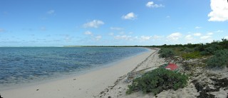 A panorama of Windlass Bight with Soldier Point that I like.
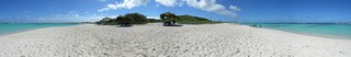 A wide panorama of Loblolly Bay and Jack Bay. Taken while standing on Jack Bay Point.
 A 360 panorama of the salt flats.
 A panorama taken from the rocks at Spring Bay. The morning version. [Is Little Trunk Bay to the left and Spring Bay to the right?]
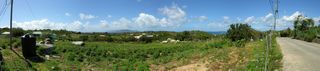 A panorama taken from the road to the Copper Mine.
 A panorama of Taylor's Bay.
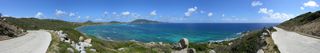 Another panorama of Taylor's Bay.
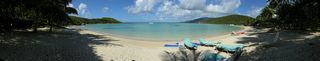 A panorama of the beach at Little Dix Bay.
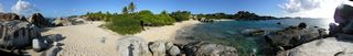 A panorama of Spring Bay. This is the afternoon version.
 Devil's Bay Beach at The Baths. The panorama version.
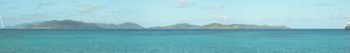 An early morning panorama with Ginger Island in the foreground.
 A panorama taken from The Top of The Baths.
 A panorama of the beach at Savannah Bay.
 A panorama looking over the north end of Virgin Gorda.
 A panorama looking west towards The Dogs. Taken from a lookout platform south of Nail Bay.
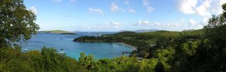 A panorama looking over Caneel Bay. You can see the sugar mill ruins in the right of the picture.
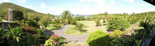 Looking over the grounds of Caneel Bay from their Equator Restaurant. (To get the exposure right I should have taken a center picture first.)
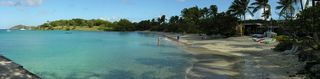 The panorama version of the beach at Caneel Bay.
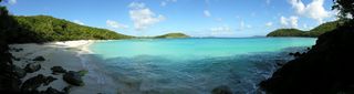 The panorama version of Hawksnest Beach. My attempts to get a straight horizon weren't successful.
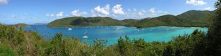 A panorama looking over Francis Bay and Maho Bay.
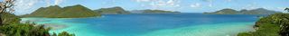 A panorama looking at Tortola from the Annaberg Sugar Mill Ruins.
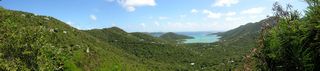 A panorama of Coral Bay from Centerline Road.
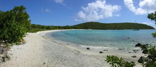 A panorama of Salt Pond Bay.
 A panorama of Friis Bay taken in front of Miss Lucy's Bar & Restaurant. The land at the far side of the bay is East End.
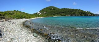 A panorama of Limetree Cove and Limetree Point.
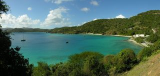 A panorama from Blackrock Hill looking northwest over Hansen Bay.
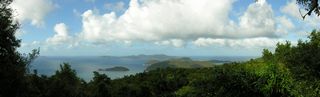 A panorama looking at Tortola from a lookout along Centerline Road.
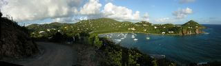 A panorama of Chocolate Hole with Bovocoap Point.
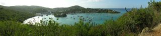 A morning panorama of Cruz Bay. An afternoon one would have been better.
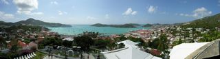 A panoramic view from the watchtower at Blackbeard's Castle looking over Charlotte Amalie and St. Thomas Harbor.
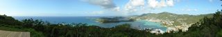 A panorama from the wooden platform at the Paradise Point scenic outlook.
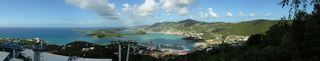 Another panorama from a lower level at the Paradise Point scenic outlook.
 A panorama of Water Island and St. Thomas from the fort.
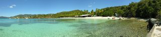 A panorama of Honeymoon Beach on Water Island.
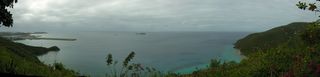 A panorama of Perserverance Bay.
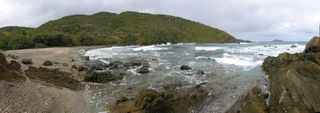 A panorama of Bordeaux Bay.
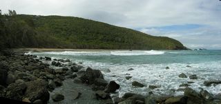 A panorama of West Caret Bay.
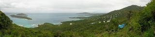 A panorama looking down at Inner Brass and Outer Brass islands. In front of them is Neltjeberg Bay. Scroll to the right and you see the mouth of Megen's Bay.
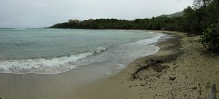 A panorama of the beach at Neltjeberg Bay.
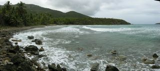 A panorama of Dorothea Bay/Beach. There are condominiums here.
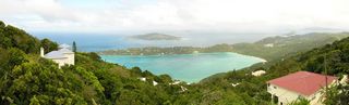 The non-panorama view of Megen's Bay from Mountain Top.
 A view of Charlotte Amalie from a scenic overlook on Route 40. This is another popular stop on the tours. More parking than Drake's Seat, so there's room for some vendors to set up.
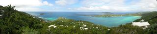 A panorama from The Great House looking at Megen's Bay.
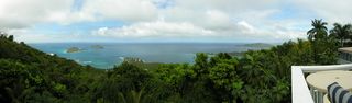 A panorama from The Great House looking at Inner Brass and Outer Brass Islands.
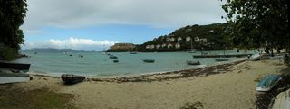 Looking out at Water Bay from Stouffer Grand Beach.
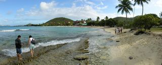 A panorama of the beach in front of the Sapphire Beach Resort & Marina. Prettyklip Point is in the background.
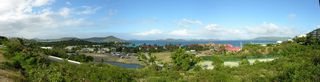 A panorama overlooking the Sapphire Beach Resort & Marina and St. John Bay
 A panorama from in front of the St. Thomas Yacht Club. Looking out on Cowpet Bay.
 A panorama of Bolongo Bay. In front of the public beach, which here is in the distance, there is sand. I shouldn't have walked so far away.
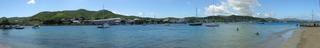 A panorama looking at Fort Christiansvaern and Christiansted from Protestant Cay.
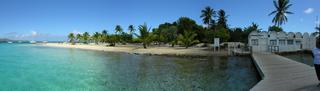 A panorama of Protestant Cay taken from the end of its dock.
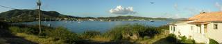 An early morning panorama of Christiansted taken from Fort Louise Augusta. The fort is to the right.
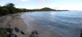 A panorama of Shoy's Beach. Shoy's Point is sticking out.
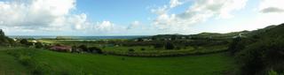 A panorama taken from the intersection of the entrance to the Green Cay Marina and Route 82. The island is Green Cay. The pond is Southgate Pond.
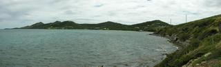 A panorama of Teague Bay.
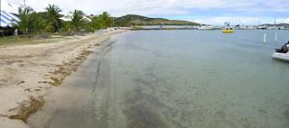 A panorama of the St. Croix Yacht Club.
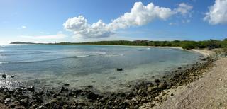 A late afternoon panorama of Manchenil Bay
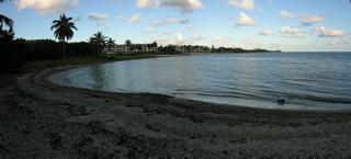 An early morning panorama looking at Sugar Beach. This is a public beach that is a popular spot for baptisms.
 A small panorama of Minster Lovell Hall. It was built by Lord William Lovell in the 1440's and was further extended by his son, Lord Francis. The last resident was Thomas Coke who moved to a new house in Holkham in Norfolk, leaving Minster Lovell to be dismantled in 1747.
 A small panorama of the Church of St. John in Burford.
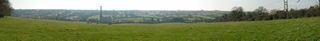 A 180° panorama from alongside A44 west of Chipping Norton. Looking at the Bliss Valley Tweed Mill. Dated 1872. Not in use.
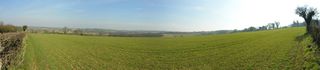 A 180° panorama from alongside the road, just east of Chastleton. Looking northeast.
 A panorama of the Model Village in Bourton-on-the-Water.
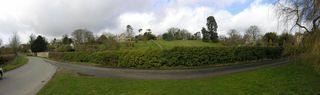 A panorama taken around Fyfield. [???] Looking at [??]
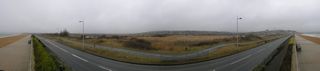 A panorama of the Lodmoor Nature Reserve.
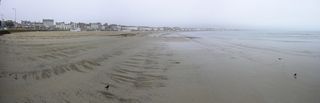 A panorama of the The Sands beach in Weymouth, Dorset.
 A panorama of Chesil Beach. I couldn't see too much.
 Taken from the end of the dock of the Metedeconk River Yacht Club on 08-Jul-06. Stitched from 27 pictures.
© Don Wiss 1999-2026. All rights reserved.